166 – Neisse Border, If You Can Get One

After 1945, Germany lost about a quarter of its pre-1933 territory to Poland and the Soviet Union. The German-Polish border was established at the so-called Oder-Neisse Line, after the two rivers that separate both states today.
Although the border is not in dispute, its establishment remains a touchy issue: millions of Germans were driven westward from Prussia, Pomerania, Silesia and other regions where their ancestors had lived for centuries. They were replaced by Soviets (in the part of East Prussia that became the Russian enclaved oblast of Kaliningrad) and by Poles who were themselves displaced by the Soviets (as the Soviet-Polish border also moved west). Nobody sympathised with the displaced Germans’ plight at the time, and even now the attitude in most of Europe (and much of Germany) is: Germany started a brutal war of conquest and lost it; it’s only natural they should be punished for it, by losing territory.
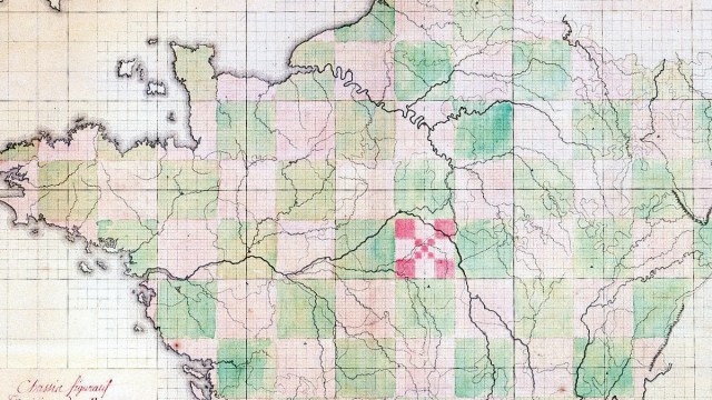
And yet, Germany post-1945 could have been a bit bigger than it actually is nowadays. In March 2007, the German newspaper Frankfurter Allgemeine Zeitung (FAZ) published an article, detailing Stalin’s plans for the post-war eastern German border. It was accompanied by a map from summer 1944, recently found in the Russian State Archives. The Soviet dictator himself drew the proposed boundaries between Germany and Poland. According to this map, the whole of Lower Silesia (Niederschlesien in German) would have remained German, and the city of Breslau (presently Wroclaw in Poland) would have become a divided (or jointly administered) German-Polish city.
Bizarrely, this proposed border would also have been an Oder-Neisse-line: in this map, Lower Silesia is separated from Poland by the Glatzer Neisse, while the present-day border is composed of the Lausitzer (or Görlitzer) Neisse, 200 km to the west. In the FAZ, Polish historian Bogdan Musial gave some background to the shifting to the west (“westverschiebung”) of the German-Polish border.
At the Conference of Tehran at the end of 1943, Roosevelt (US), Churchill (UK) and Stalin (USSR) agreed in principle on moving the Polish-German border (and dividing Germany itself in a western and an eastern zone of influence). A border on the Neisse was agreed upon, without specifying whether this would be the western or eastern of both rivers.
Only at the Yalta Conference in February 1945 did Stalin insist on the western of both eponymous rivers – in part to compensate Poland for his insistance to include the ancient Polish city of Lwow in the Soviet Union. The western powers were adamant in their opposition to the western Neisse plan.
But in the summer of 1945, at the Potsdam Conference, Stalin pushed through his modified proposal. This push westward, hard to swallow for many Germans (and indeed not recognised by West Germany until 1970), gave Stalin additional leverage over Poland, the untouchability of its new, controversial western borders his army could be counted on to guarantee.
The new border also had a practical advantage: it was the shortest, and therefore easiest to defend border between Germany and Poland, only 472 km long. Finally, it should be noted that the present border is not the westernmost of all proposed borders: one plan called for the inclusion in Poland of areas west of the Lausitzer Neisse, i.c. the region around Cottbus and Bautzen, home of the Sorbs, a Slavic minority in Germany.